16531 Russell Street
PO Box 66
St. Paul, Virginia 24283
Phone: 276-762-5297
Fax: 276-762-0479
Trails
Choose Your Own Adventure with hundreds of miles of trails twist, meander, dip and climb through the peaks and valleys around Asheville. You can take your pick from peaceful hikes along the Clinch River and technical scrambles up steep terrain; hikes that are short and sweet and multi-day adventures. Our trail system offers something for everyone whether it is hiking, biking or ATV trails you are looking to discover.

Mountain View Trail System
Spearhead Trails Premiere OHV Trail System
Mountain View has expanded to over 100 tree-lined miles, with 10 miles of dedicated single track for dirt bikes. This system has a nice mix of green, blue, and black trails, great views, and fun for all! The trailhead is located in our ATV-friendly town, just off 3rd Avenue, and you can ride your OHV to your room, the store, and to get gas or food.
All of Spearhead Trail Systems are multi-use, meaning they are open to mountain bikers and hikers as well. Horses are not allowed on OHV trail systems due to safety concerns.
Permits are required and may be purchased on-line or at several retailers in town. For more information, visit SpearheadTrails.com.

Sugar Hill Loop Trail
This well-maintained hiking and biking trail extends nearly 8 miles around and over Sugar Hill, the large ridge north of Oxbow Lake Park. The trail climbs steeply to the ridge and then curves back around near the dam at the eastern end of Oxbow lake. The Lower River Trail traverses the banks of the State Scenic Clinch River. This river is home to several species of endangered freshwater mussels. Feel free to observe them from the bank. Sugar Hill Loop Trail traverses dense hardwood forest filled with excitement for the patient observer. The trees hold numerous breeding songbirds including red-eyed vireo, wood thrush, yellow-billed cuckoo, and some warblers as well as fox squirrel.
The Sugar Hill and Clinch River Trails have been nominated as state birding and wildlife viewing trails because of the wide variety of flora and fauna found along the way.
The trailhead for the Sugar Hill Loop Trail is located just west of the Oxbow Lake Loop Trail. Parking is available at the Oxbow Lake Park (shared parking lot) or at the west end of the lake.

Bluebell Island - Part of St. Paul on the Clinch Trails
visitors will stroll along Lick Creek as it flows toward the Clinch River. The trail follows the creek beneath a railroad bridge built in 1912, then plunges deeper into the riverside forest. Here, the trail forks, with bikers branching right onto another trail and hikers staying left.
The hiking trail continues along the Clinch River and offers a view of Bluebell Island, a 1.3-acre area owned by St. Paul that is now part of a conservation easement with the Nature Conservancy. Its namesake belongs to a flower that blooms in late spring along the trail. The path meanders along the river before emerging from the woods at A.R. Matthews Park, where it continues tracking the river before jotting up a hill and past an old red railroad caboose toward downtown St. Paul. The trail passes through the heart of downtown before rejoining the Clinch River near its terminus.
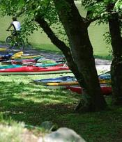
Oxbow Lake - Canoe/Small Boat Access, Fishing, Picnic Areas, Walking & Biking
Oxbow Lake Park is a city-owned park that includes a wetland and forest complex adjacent to the Clinch River. Because of its well maintained trail system, it is a popular destination for many of Saint Paul’s residents. The Oxbow Lake trail is a paved, wheelchair-accessible mile-long loop. Restroom facilities are located at the parking area. The park provides residence to a large selection of big and showy dragonflies including blue dasher, slaty and widow skimmers, and prince baskettail. Butterflies include black swallowtail, zebra swallowtail, eastern tailed-blue, and clouded sulphur. The lake holds a few feral ducks and geese but could be better for waterfowl in the winter and during migration. The surrounding fields, bushes, and hardwood forest hold orchard oriole, ruby-throated hummingbird, eastern kingbird, red-eyed vireo, and wood thrush. The lake itself can attract barn and rough-winged swallows as well as the occasional purple martin. The east end of the lake provides access to three additional trails that traverse both riverine and mountain habitats.
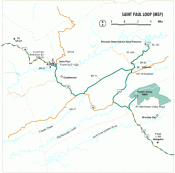
Virginia Birding & Wildlife Trails - St. Paul Loop
The Saint Paul Loop offers six excellent sites in proximity to the Town of Saint Paul. Included in this mix are state and city lands likely to be productive for wildlife watching. The loop variety includes both extensive areas and relatively small venues. Wetlands, montane and woodland habitats can be found on this loop. Elevation ranges vary, with Sugar Hill Loop Trail climbing above and providing a stunning view of the Clinch River Valley. The Pinnacle towers above Big Cedar Creek and is surrounded by a fragile ecosystem. There are several species of rare and endangered species resident here, including the magnificent but elusive hellbender.
Four of the six sites are located in or about St. Paul. These include:
Site MSP03 Elevation: 1427 ft. Oxbow Lake Park is a town-owned park that includes a wetland and forest complex adjacent to the Clinch River. Because of its well maintained trail system, it is a popular destination for many of Saint Paul's residents. The Oxbow Lake trail is a paved, wheelchair-accessible mile-long loop. Restroom facilities are located at the parking area. The park provides residence to a large selection of big and showy dragonflies including blue dasher, slaty and widow skimmers, and prince baskettail. Butterflies include black swallowtail, zebra swallowtail, eastern tailed-blue, and clouded sulphur. The lake holds a few feral ducks and geese but could be better for waterfowl in the winter and during migration. The surrounding fields, bushes, and hardwood forest hold orchard oriole, ruby-throated hummingbird, eastern kingbird, red-eyed vireo, and wood thrush. The lake itself can attract barn and rough-winged swallows as well as the occasional purple martin. The east end of the lake provides access to three additional trails that traverse both riverine and mountain habitats.
Site MSP04 Elevation: 1454 ft. This well-maintained hiking and biking trail extends around and over Sugar Hill, the large ridge north of Oxbow Lake Park. The trail climbs steeply to the ridge and then curves back around near the dam at the eastern end of Oxbow lake. The Lower River Trail traverses the banks of the State Scenic Clinch River. This river is home to several species of endangered freshwater mussels. Feel free to observe them from the bank, but please to not touch or disturb them. Sugar Hill Loop Trail traverses dense hardwood forest filled with excitement for the patient observer. The trees hold numerous breeding songbirds including red-eyed vireo, wood thrush, yellow-billed cuckoo, and some warblers as well as fox squirrel. This site offers a variety of unusual trees seldom found in this part of the Appalachians. Many of these trees, including the Kentucky coffee tree, are labeled by interpretive signage. In the few areas where sunlight breaks through the canopy, dragonflies, butterflies and other striking insects can be found. Moister areas within leaf litter and fallen debris hold a variety of salamanders and snakes. The trailhead for the Sugar Hill Loop Trail is located just west of the Oxbow Lake Loop Trail. Parking is available at the Oxbow Lake Park (shared parking lot) or at the west end of the lake.
Site MSP05 Elevation: 1525 ft. This heavily vegetated wetlands lies next to the Saint Paul School complex, making it an ideal venue for education. Its location in the center of a residential neighborhood is also advantageous for members of the local community. The Wetlands Estonoa Learning Center project is a nationally acclaimed student-based wetlands and outdoors education center that has a short loop trail. Several large hardwood species, such as yellow poplar, oaks, and maples surround the lake. These deciduous trees host a number of eastern woodland birds including red-eyed vireo, gray catbird, and downy woodpecker. While the lake fringes of the wetlands are heavily reeded, the center of the lake is covered with floating vegetation that provides numerous resting places for the many large dragonflies found in the area. Eastern pondhawk, slaty skimmer and blue dasher are especially numerous at Wetlands Estonoa. The moister areas also hold rare treasures such as the eastern mud salamander. For more information about Wetlands Estonoa, visit their website at https://www.wetlandsestonoa.com/.
Site MSP06 Elevation: 1461 ft. At present, the area includes access to the eastern bank of the State Scenic Clinch River, which is lined with numerous large hardwood trees. Pileated woodpecker, flycatchers, vireos and thrushes can be found along this river embankment. There are several species of endangered mussels in the Clinch River. Feel free to observe them from above, but please do not disturb them. The slightly overgrown dirt road that runs alongside the river has numerous small puddles ideal for frogs such as green and pickerel frogs. Open, grassier areas, where sunlight is able to penetrate through openings in the forest canopy, are frequented by numerous damselflies such as calico pennant and slaty skimmer. When wildflowers within these areas are in bloom, look for butterflies such as zebra swallowtail and red-spotted purple.
This information was provided by the Virginia Department of Game and Inland Fisheries.For complete information on the St. Paul Loop, including detailed directions to and descriptions of sites MSP01 Hidden Valley Lake and MSP02 Pinnacle Natural Area Preserve, visit the Virginia Department of Game and Inland Fisheries website.

